PATH ::: home / science / old highligts
PATH ::: home / science / old highligts |
||
HIGHLIGHT OF APRIL 2014
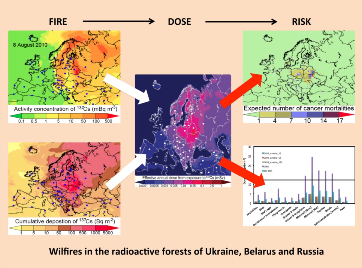
This is the first study that quantifies the impact of wildfires in the highly radioactive forests of Ukraine, Belarus and Russia on the human population and the environment. Since the Chernobyl accident in 1986, extreme contamination of forests in Ukraine, Belarus and Russia resulted in evacuation and lack of forest management. Currently, trees cover more than 70% of these areas, and Climate Change suggests increasing fire risks. These worrying findings call on the scientific community and the European responsible authorities to study the consequences of wildfire scenarios and quantify the health risks for humans and animals. The global aerosol model LMDZORINCA was used to predict the 4D distribution of 137Cs following the fire scenarios at a resolution of 0.66°×0.51° (zoom centered over Europe) over 19 vertical layers. The spatial deposition density of 137Cs (Bq m-2) in these forests is currently well known either from measurement or modelling and is multiplied by the burnt area (m2) read from MODIS to estimate 137Cs emissions. We estimate that up to 4.5 PBq of 137Cs can migrate over Europe, which constitutes a serious accident in the International Nuclear Events Scale (INES). A number between 20 and 240 may suffer from solid cancers in Europe, of which 10 – 170 may be fatal. This is very important if one takes into account that the global excess lifetime fatalities from the recent accident in Japan have been estimated to be between 220 to 520. Increased radiation levels have changed the animal population regime in the area since 1986. The situation near these forests will be exacerbated after a major fire, due to the Chernobyl-remaining refractory elements (such as Pu and Am), also trapped there. |
|
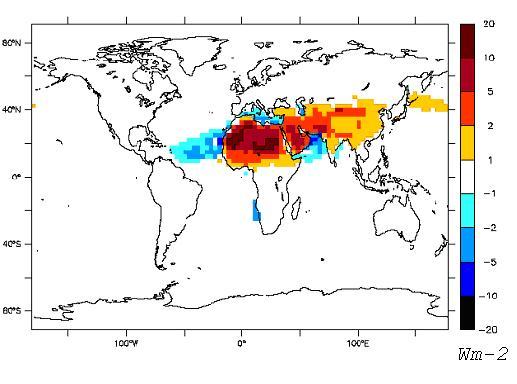
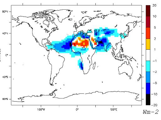
HIGHLIGHT OF NOVEMBER 2013
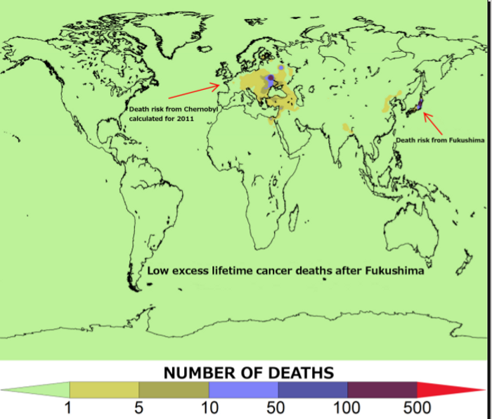
Description: Global death (or mortality) risk from radiation cancer estimated after the Fukushima accident in Japan (2011). Risks were calculated by combining relative risks and functions of the Linear No-Threshold (LNT) model with the results of the LMDZORINCA simulations for the accident. Two of the most important radionuclides, that constitute the global fallout, have been examined (134Cs and 137Cs). The resolution of the model version used here is 2.5ox1.3o over 39 vertical levels. Our results showed that 360 - 850 cancer incidents are expected, of which 220 - 520 may be fatal. This is the first reported map that localizes cancer risk after Fukushima, whereas comparisons with other estimation (e.g. Ten Hoeve and Jacobson, 2012) show excellent coherence of our results. |
|
HIGHLIGHT OF June 2013
La minéralogie des poussières désertiques joue un rôle important dans le calcul des effets radiatifs direct et indiract, en chimie hétérogène et pour les cycles biogéochimiques. Cette minéralogie dépend en partie de la minéralogie des régions sources de poussières et aussi de la fractionation en taille pendant les processus d'érosion et de transport atmosphérique. Nous présentons dans ce travail une base de données caractérisant les fractions argile et limon pour chaque type de sol à l'échelle globale en terme d'abondance de 12 minéraux importants dans les interactions poussière-climat : quartz, feldspath, illite, montmorillonite, kaolinite, chlorite, vermiculite, mica, calcite, gypse, hématite, et goethite. L'information minéralogique a été compilée à partir de données publiées dans des papiers scientifiques et nous avons étendu cette base de données en appliquant des règles explicites. afin de caractériser le plus grand nombre d'unités de sol posssibles. Nous présentons trois réalisations de cartes minéralogiques, qui prennent en compte les incertitudes des données minéralogiques. Nous analysons l'effet de ces variations minéralogiques sur l'albédo de simple diffusion des poussières désertiques et donc sur leur forçage radiatif. |
|
HIGHLIGHT OF February 2013
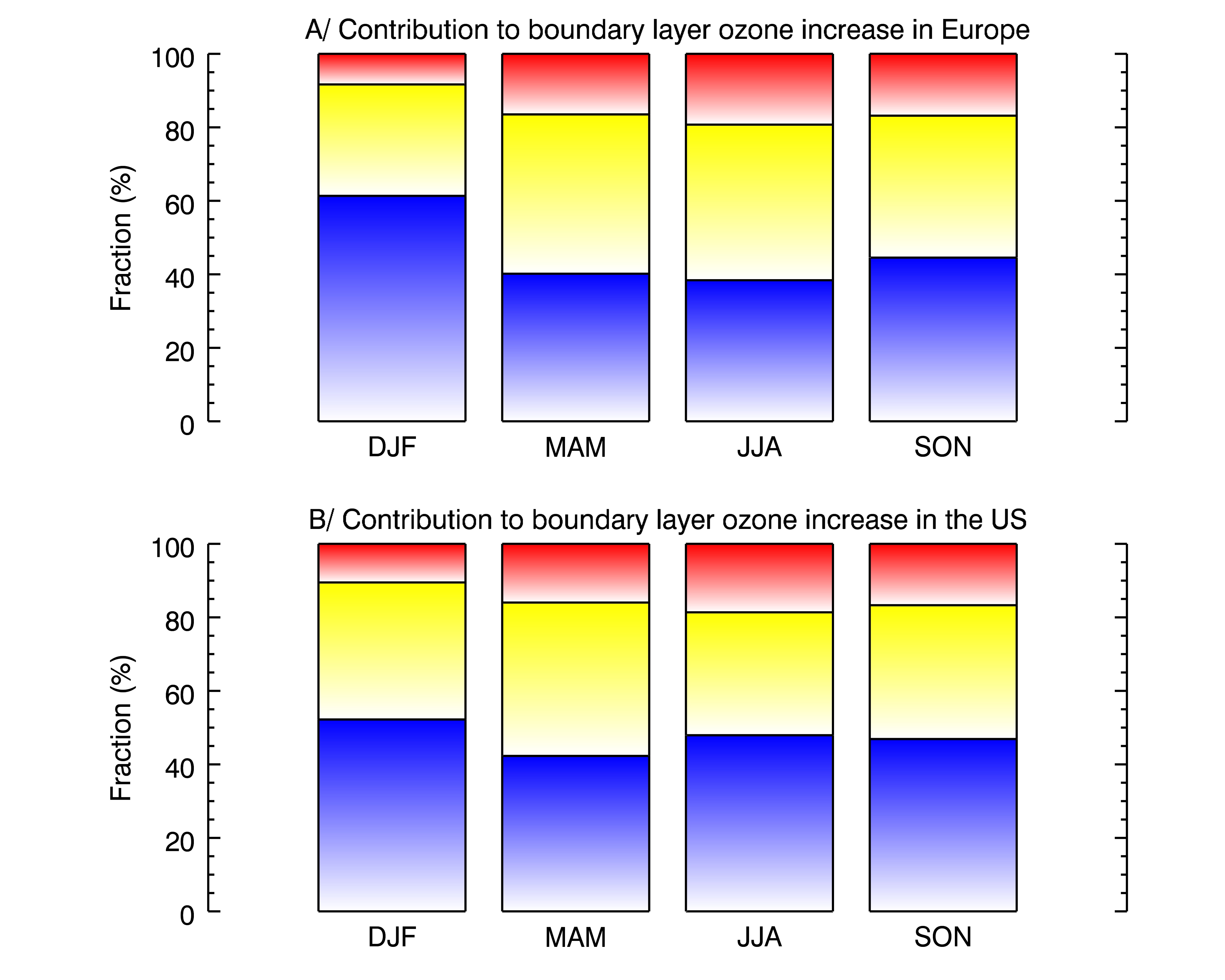
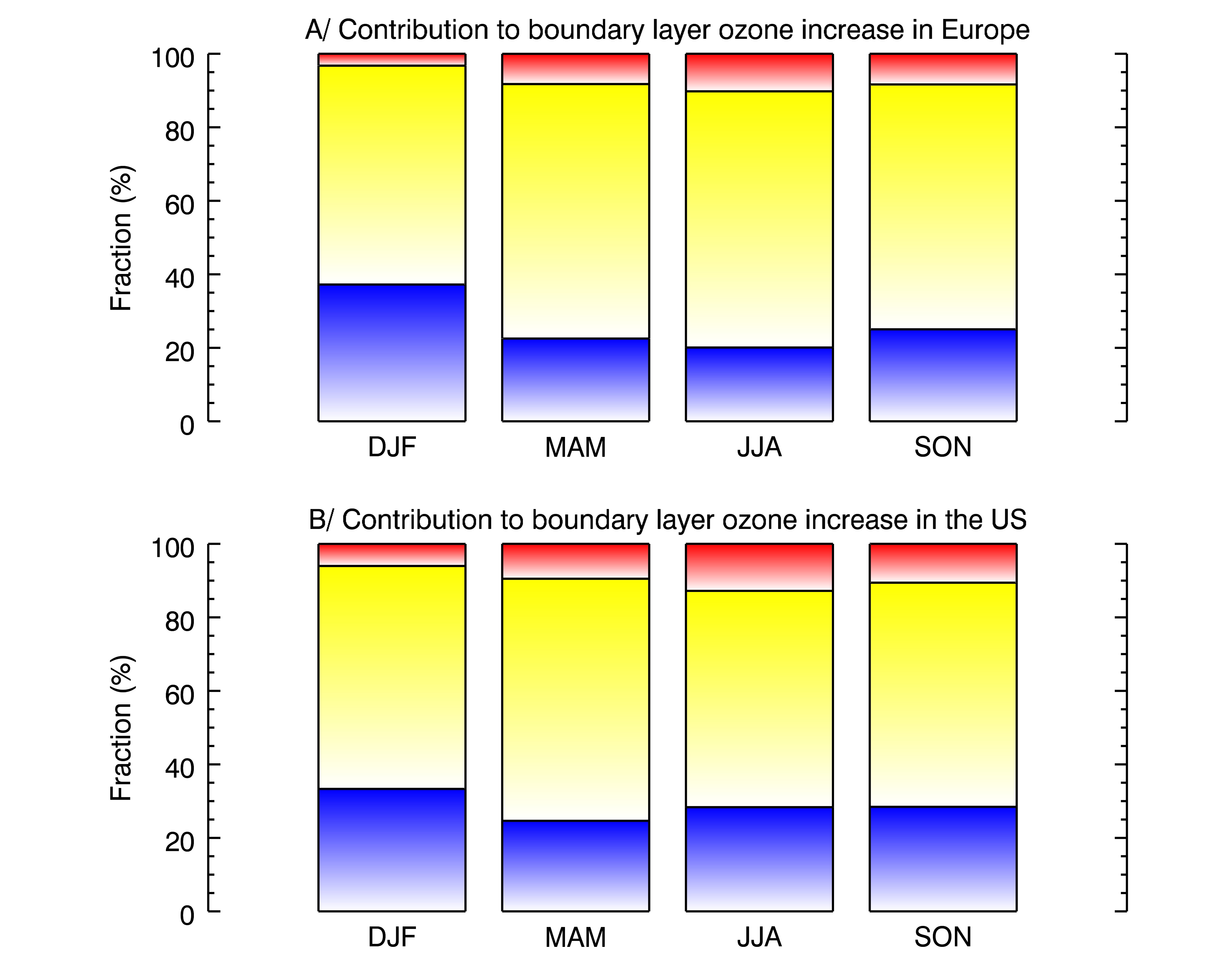
Relative contribution (%) of aircraft (blue), shipping (yellow), and road (red) emissions to boundary layer ozone increase due to transport in Europe and in the United States in 2050 under business as usual scenario A1B (left) and the mitigation scenario B1 ACARE (right). The ozone change is integrated from the ground level to the pressure of 910 hPa (lowest three model levels). Hauglustaine and Khoffi (2012). |
|
HIGHLIGHT OF NOVEMBER 2009
Model simulations, climatologies, and integrated products |
 |
HIGHLIGHT OF APRIL 2008
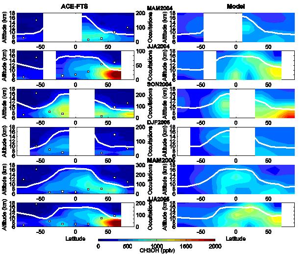
Zonal mean CH3OH volume mixing ratio profiles observed
by the ACE-FTS (left) and simulated with the LMDz-INCA
model (right) for each season from March 2004 to August
2005. The modeled profiles used are interpolated at the
measurement locations. The number of profiles averaged
in each 20° latitude band is indicated on the left
panels (white squares). Only averages with more than
10 profiles are displayed. A mean tropopause height
is calculated based on NCEP meteorological fields for
each measured methanol profile and from the model for
the calculated distributions (white line). |
 |
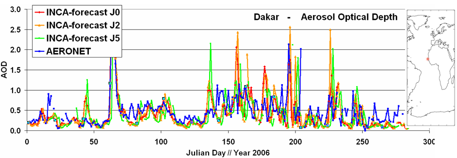
HIGHLIGHT OF NOVEMBER 2007
The dust forecast performed daily with the experimental INCA chemical weather forecast is compared to the Aeronet sun photometer measurements in Dakar,M'Bour,Africa (acknowledgement Didier Tanre LOA). The analysis of the initialisation day (J0) and of the forecast +2 days (J2) and +5 days (J5) is compared to the 2006 annual cycle of aerosol optical depth. Despite a degradation of the AOD forecast with increasing time forecasted the global model can reproduce the general characteristics of the dust appearance at the borders of the Sahara. |
 |
|
HIGHLIGHT OF JANUARY 2007
|
|
|
Comparaison de l'effet radiatif des poussières tel que calculé
auparavant en utilisant l'indice de réfraction proposé par
Patterson and Volz (à droite) et avec les calculs optiques
d'un mélange interne compose de 1.5% en volume d'hématite (à gauche). |
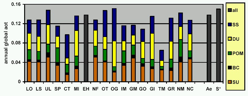
HIGHLIGHT OF JUNE 2006
Individual contributions of the five aerosol components (SS-seasalt, DU-dust, POMparticulate organic matter, BC-black carbon, SU-sulfate) to the annual global aerosol optical thickness at 550nm (AOD) from different AeroCom models as compared to Aeronet (Ae) sun photometer and a satellite composite (S*) observations (From Kinne et al. 2006). LS represents the INCA model simulation. The models have quite a different understanding of how to derive global AOD from aerosol components. The just published AeroCom papers Kinne et al. ACP, 2006 and Textor et al. ACP, 2006 document considerable diversity in global aerosol models and the need to further improve aerosol parameterizations. |
 |
HIGHLIGHT OF FEBRUARY 2006
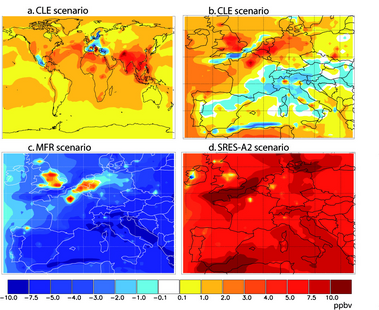
Monthly mean surface O3 changes in July 2030 (compared with July 2001) (a) at the global scale using LMDzINCA, for the "current legislation" scenario; (b)(c)(d) over Europe using the regional CTM CHIMERE forced with LMDzINCA boundary conditions, for, respectively, the "current legislation" scenario, the "maximum feasible reductions" scenario and the SRES-A2 scenario. (Sophie Szopa et al., GRL submitted in January) |
 |
HIGHLIGHT OF NOVEMBER 2005
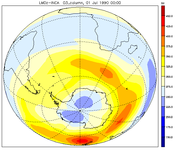
A first simulation of the Antarctic ozone hole formation with the 50 level version of the coupled chemistry-climate model LMDz-INCA including the stratospheric gas phase and heterogeneous chemistry. The figure shows the onset of the polar vortex and the formation of the ozone hole for 1990 Cl and Br conditions. A maximum ozone destruction with total ozone column as low as 150-175 DU is reached in mid-october October. The dilution of the ozone hole appears in November-December. (Contact: D. Hauglustaine, LSCE). |
 |
|
HIGHLIGHT OF OCTOBER 2005
|
|
|
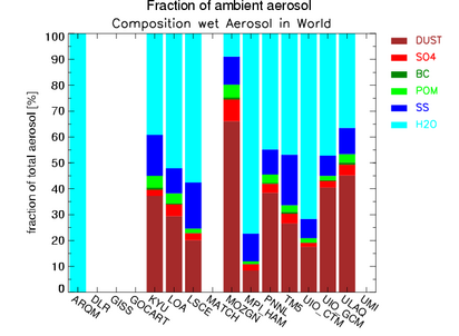
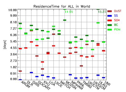
Simulation results of global aerosol models have been assembled in the framework of the AeroCom intercomparison exercise. The life cycles of dust, sea salt, sulfate, black carbon and particulate organic matter as simulated by sixteen global aerosol models. The diversities among the models for the sources and sinks, burdens, particle sizes, water uptakes, and spatial dispersals have been established. The established diversities are highest for: |
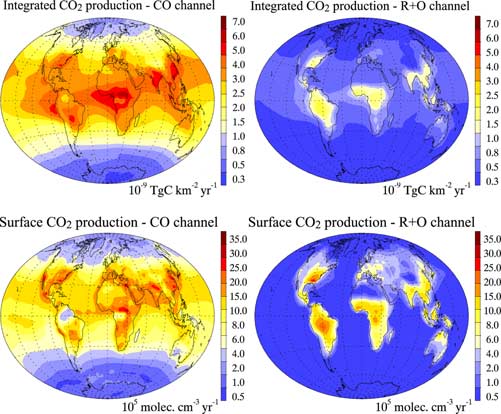
HIGHLIGHT OF SEPTEMBER 2005
Horizontal distribution of the annual mean in situ CO2 production rate for (left) the CO channel and (right) the radicals and ozonolysis channel. (top) Column integrated production rates (10**-9 TgC km**-2 yr**-1); (bottom) annual mean production rates at the surface (10**5 molecules cm**-3 yr**-1). Results are taken from the lowermost model level representing a layer height of approximately 140 meters. (see full description in G. Folberth, D. A. Hauglustaine, P. Ciais, and J. Lathière, On the role of atmospheric chemistry in the gloabl CO2 budget, 2005) |
 |
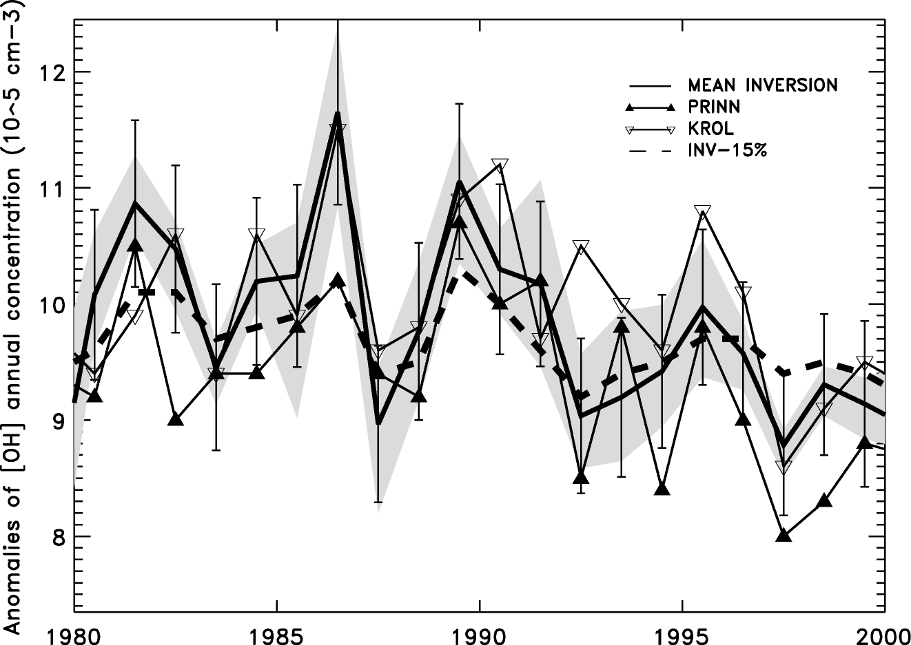
HIGHLIGHT OF SUMMER 2005
Annual global OH anomalies from mean inversion (solid line) compared with estimates from Prinn et al. (2001) (a) and from Krol et al. (2003) (b). Grey zone is the envelope of all 16 inversions. (see full description in P. Bousquet, D. A. Hauglustaine, P. Peylin, C. Carouge, and P. Ciais, Two decades of OH variability as inferred by an inversion of atmospheric transport and chemistry of methyl chloroform, 2005) |
 |
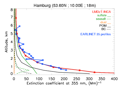
HIGHLIGHT OF APRIL 2005
Simulation with INCA of vertical aerosol extinction profile at EARLINET
site Hamburg, for year 2000. Observations taken by the lidar group, Jens
Boesenberg, Volker Matthias and colleagues from the Max-Planck Institute
of Hamburg. The averaging over longer periods provides a stable way to compare
global model results with local lidar observations. (see full description
in Guibert, S., V. Matthias, M. Schulz, J. Bösenberg, R. Eixmann,
I. Mattis, G. Pappalardo, M. R. Perrone, N. Spinelli, and G. Vaughan ,The
vertical distribution of aerosol over Europe - Synthesis of one year of
EARLINET aerosol lidar measurements and aerosol transport modeling with
LMDzT-INCA, Atmos. Environ., in press, 5. ) |
 |
|
|
|
| © Laboratoire des Sciences du Climat et de l'Environnement | |
 lsce.ipsl.fr) & S. Szopa (sophie.szopa